History


The Chinese were already familiar with the techniques of wall-building by the time of the Spring and Autumn Period, which began around the 8th century BC. During the Warring States Period from the 5th century BC to 221 BC, the states of Qi, Yan and Zhao all constructed extensive fortifications to defend their own borders. Built to withstand the attack of small arms such as swords and spears, these walls were made mostly by stamping earth and gravel between board frames. Qin Shi Huang conquered all opposing states and unified China in 221 BC, establishing the Qin Dynasty. Intending to impose centralized rule and prevent the resurgence of feudal lords, he ordered the destruction of the wall sections that divided his empire along the former state borders. To protect the empire against intrusions by the Xiongnu people from the north, he ordered the building of a new wall to connect the remaining fortifications along the empire's new northern frontier. Transporting the large quantity of materials required for construction was difficult, so builders always tried to use local resources. Stones from the mountains were used over mountain ranges, while rammed earth was used for construction in the plains. There are no surviving historical records indicating the exact length and course of the Qin Dynasty walls. Most of the ancient walls have eroded away over the centuries, and very few sections remain today. Later, the Han, Sui, Northern and Jin dynasties all repaired, rebuilt, or expanded sections of the Great Wall at great cost to defend themselves against northern invaders.
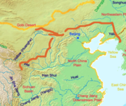
The Great Wall concept was revived again during the Ming Dynasty following the Ming army's defeat by the Oirats in the Battle of Tumu in 1449. The Ming had failed to gain a clear upper-hand over the Manchurian and Mongolian tribes after successive battles, and the long-drawn conflict was taking a toll on the empire. The Ming adopted a new strategy to keep the nomadic tribes out by constructing walls along the northern border of China. Acknowledging the Mongol control established in the Ordos Desert, the wall followed the desert's southern edge instead of incorporating the bend of the Huang He.
Unlike the earlier Qin fortifications, the Ming construction was stronger and more elaborate due to the use of bricks and stone instead of rammed earth. As Mongol raids continued periodically over the years, the Ming devoted considerable resources to repair and reinforce the walls. Sections near the Ming capital of Beijing were especially strong.[10]
During the 1440s–1460s, the Ming also built a so-called "Liaodong Wall". Similar in function to the Great Wall (whose extension it, in a sense, was), but more basic in construction, the Liaodong Wall enclosed the agricultural heartland of the Liaodong province, protecting it against potential incursions by Jurched-Mongol Oriyanghan from the northwest and the Jianzhou Jurchens from the north. While stones and tiles were used in some parts of the Liaodong Wall, most of it was in fact simply an earth dike with moats on both sides.[11]
Towards the end of the Ming Dynasty, the Great Wall helped defend the empire against the Manchu invasions that began around 1600. Under the military command of Yuan Chonghuan, the Ming army held off the Manchus at the heavily fortified Shanhaiguan pass, preventing the Manchus from entering the Chinese heartland. The Manchus were finally able to cross the Great Wall in 1644, when the gates at Shanhaiguan were opened by Wu Sangui, a Ming border general who disliked the activities of rulers of the Shun Dynasty. The Manchus quickly seized Beijing, and defeated the newly founded Shun Dynasty and remaining Ming resistance, to establish the Qing Dynasty.
In 2009, an additional 290 kilometres (180 miles) of previously undetected portions of the wall, built during the Ming Dynasty, were discovered. The newly discovered sections range from the Hushan mountains in the northern Liaoning province to Jiayuguan in western Gansu province. The sections had been submerged over time by sandstorms that moved across the arid region.[12]
Under Qing rule, China's borders extended beyond the walls and Mongolia was annexed into the empire, so construction and repairs on the Great Wall were discontinued.
Notable areas

The following three sections are in Beijing municipality, which were renovated and which are regularly visited by modern tourists today.
- "North Pass" of Juyongguan pass, known as the Badaling. When used by the Chinese to protect their land, this section of the wall has had many guards to defend China’s capital Beijing. Made of stone and bricks from the hills, this portion of the Great Wall is 7.8 meters (25.6 ft) high and 5 meters (16.4 ft) wide.
- "West Pass" of Jiayuguan (pass). This fort is near the western edges of the Great Wall.
- "Pass" of Shanhaiguan. This fort is near the eastern edges of the Great Wall.
- One of the most striking sections of the Ming Great Wall is where it climbs extremely steep slopes. It runs 11 kilometers (7 mi) long, ranges from 5 to 8 meters (16–26 ft) in height, and 6 meters (19.7 ft) across the bottom, narrowing up to 5 meters (16.4 ft) across the top. Wangjinglou is one of Jinshanling's 67 watchtowers, 980 meters (3,215 ft) above sea level.
- South East of Jinshanling, is the Mutianyu Great Wall which winds along lofty, cragged mountains from the southeast to the northwest for approximately 2.25 kilometers (about 1.3 miles). It is connected with Juyongguan Pass to the west and Gubeikou to the east.
- 25 km west of the Liao Tian Ling stands of part of Great wall which is only 2~3 stories high. According to the records of Lin Tian, the wall was not only extremely short compared to others, but it appears to be silver. Archeologists explain that the wall appears to be silver because the stone they used were from Shan Xi, where many mines are found. The stone contains extremely high metal in it causing it to appear silver. However, due to years of decay of the Great Wall, it is hard to see the silver part of the wall today.
Another notable section lies near the eastern extremity of the wall, where the first pass of the Great Wall was built on the Shanhaiguan (known as the “Number One Pass Under Heaven”), the first mountain the Great Wall climbs. Jia Shan is also here, as is the Jiumenkou, which is the only portion of the wall that was built as a bridge. Shanhaiguan Great Wall is called the “Museum of the Construction of the Great Wall”, because of the Meng Jiang-Nu Temple, built during the Song Dynasty.


